

Storm surge forecasts predict historic flooding for beaches in Hurricane Florence’s path, up to 13 feet above normal sea level, as the storm is headed for landfall on the Carolinas’ coasts Friday.
The National Hurricane Center (NHC) on Thursday downgraded Florence to a Category 2 storm with wind speeds above 110 miles per hour, with a 500-mile-wide swathe set to trigger rainfall across the Carolinas.
On Tuesday, storm surge warnings were issued from South Carolina to Virginia. These abnormally high waters that accompany some hurricanes can be deadly — the flooding they cause, together with rainfall, account for most hurricane deaths.
The governors of North Carolina, South Carolina, and Virginia all declared states of emergency in advance of the storm. The US Navy sent about 30 ships out to sea to weather the storm from the naval base at Norfolk, Virginia.
“We are bracing for a hard hit,” North Carolina Gov. Roy Cooper said in a statement announcing a request for a federal disaster declaration ahead of the storm, which has triggered coastal evacuations. “The forecast places North Carolina in the bull’s eye of Hurricane Florence, and the storm is rapidly getting stronger.”

"North Carolina is taking #HurricaneFlorence seriously, and you should too. Get ready now." - Gov. Cooper. https://t.co/5tX7pk3rsJ
“We could see record storm surge for North Carolina,” coastal geologist Robert Young of Western Carolina University said in an analysis of possible storm impacts shared with reporters. Young estimated that Florence could cause storm surges similar to those from Hurricane Hugo in 1989 and inland flooding matching that of Hurricane Floyd in 1999.
“If the projected track and intensity modeling holds, this will be a worst-case scenario storm.”

This is terrifying. "...a mid-strength Category 4 hurricane with 145 mph winds hitting at high tide, in a worst-case scenario, can generate a storm tide in excess of twenty feet above ground level along the entire coast of South Carolina." https://t.co/9NrbK13Hyl
Hurricane Florence promises big surges for a number of reasons. First, it appears headed squarely for the coast, an approach that typically piles up water in front of a storm, unlike ones that travel sideways alongside a coast. Second, the counterclockwise spin of the storm will feed water into the center of the storm just as it arrives onshore. Finally, the coastal geology of North Carolina’s Outer Banks features bays and barrier islands that act to build up tides, rather than letting water escape out to sea.
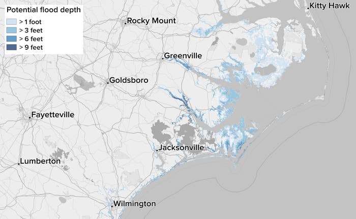
Experimental maps from the NHC, showing potential inundation above ground level from the storms, add to the concern. They give preliminary estimates of the potential amount of water that might cover a locale, subject to the shifting track of the storm. (BuzzFeed News will update this post with projected changes; check for updates.)
The hurricane center stresses that it can’t account for all of the factors, including wind and waves, that will determine the depth of the flood at any location. These may lead to flooding that differs from these projections.
Everyone living in a coastal evacuation zone should follow local evacuation recommendations for safety and pay attention to the NHC’s storm surge warnings and watches.
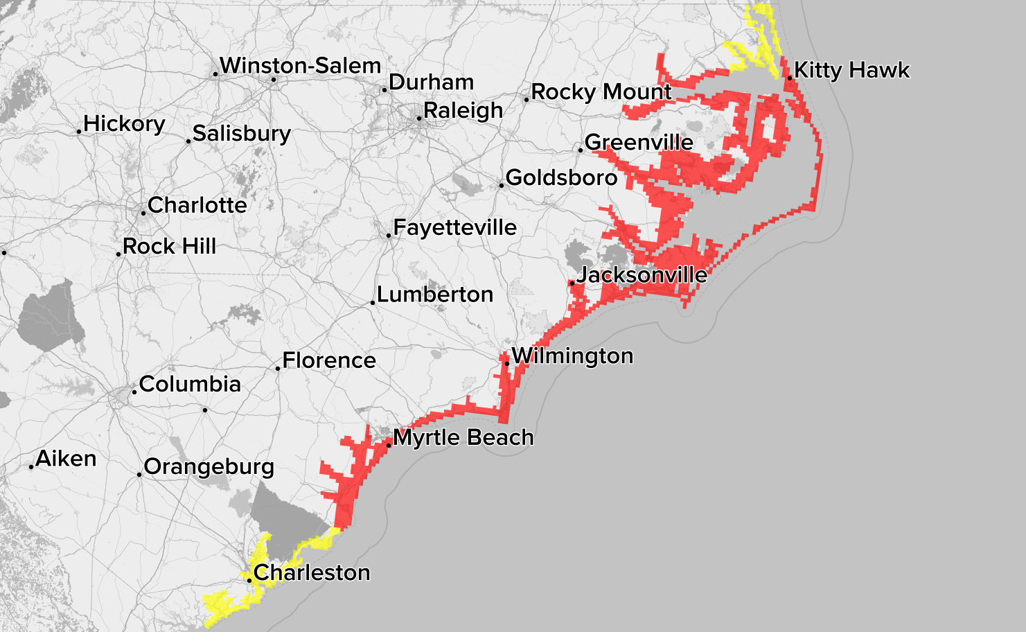
As of Thursday morning, the eye of storm seemed likely to hit land near Wilmington in North Carolina and Myrtle Beach in South Carolina.
Wilmington, North Carolina
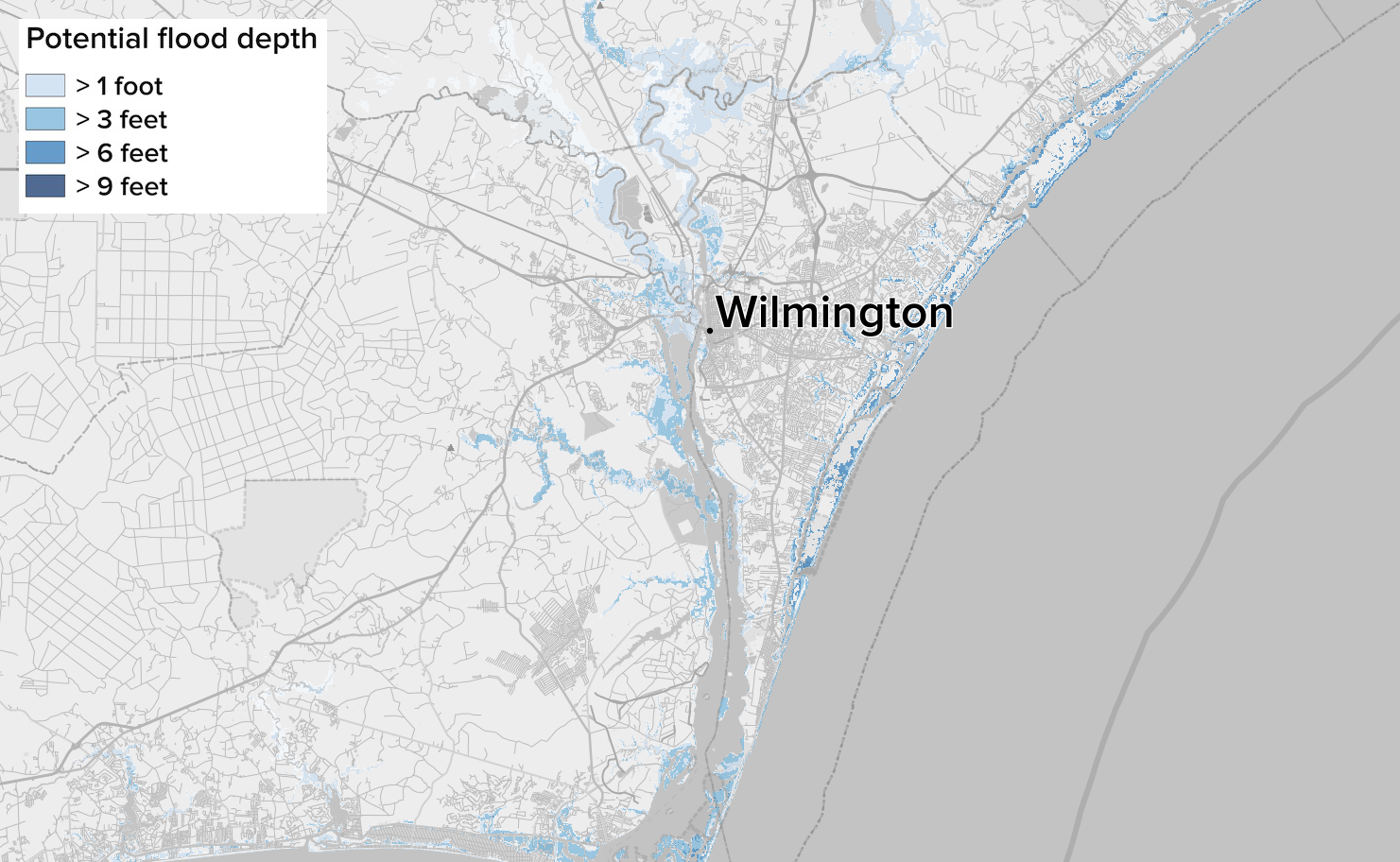
Evacuations have taken place from this port city of 120,000. Barrier islands guarding the city may see inundations deeper than nine feet in the projections, and low-lying areas along the Cape Fear River might see waters rise above three feet.
Greenville, North Carolina
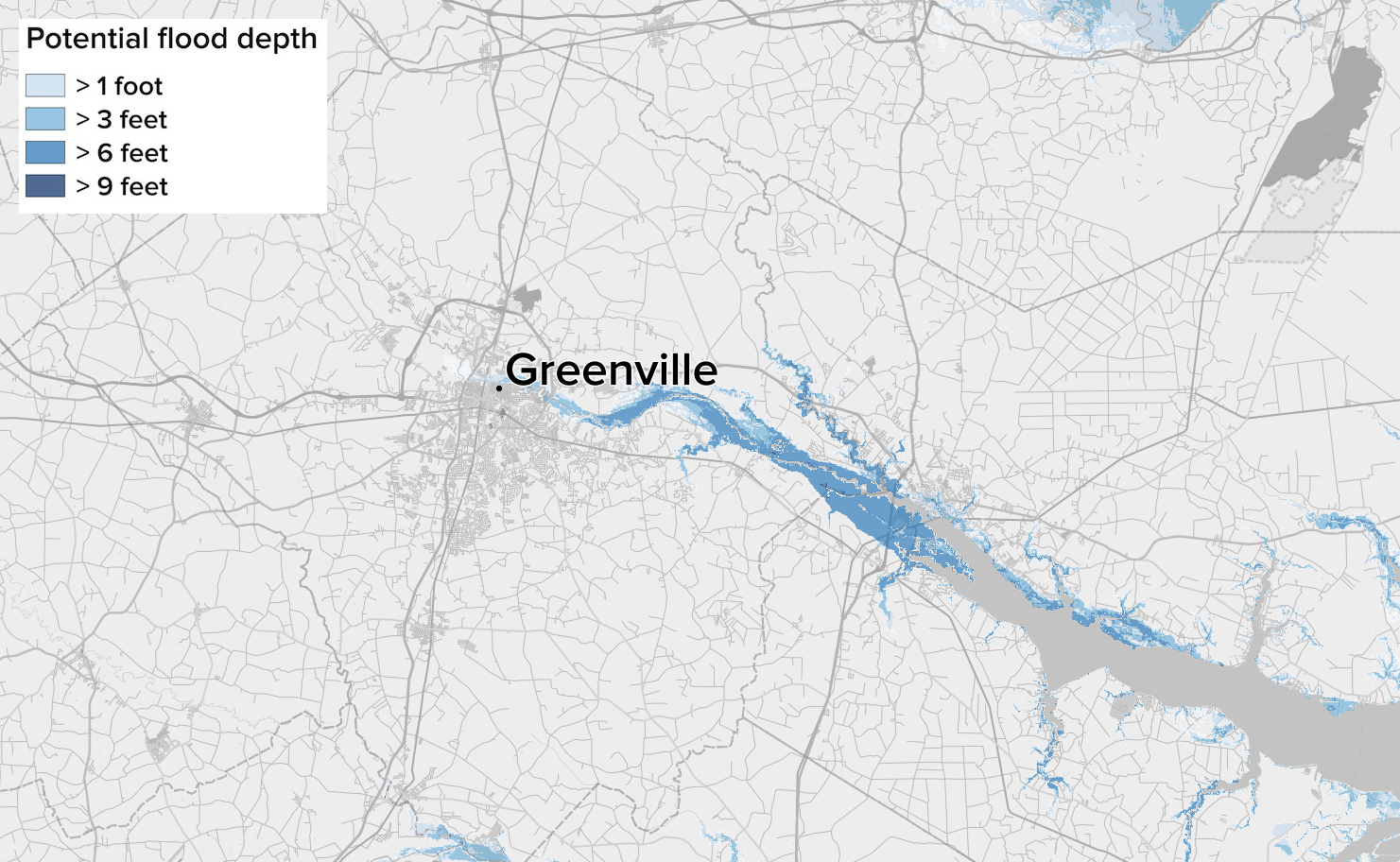
The channel of the Tar River, the site of repeated past floods, threatens to concentrate a storm surge on this town of 90,000 people. Even though it is well inland, portions of the channel extending into the town could again see waters rise more than six feet above ground level.
Charleston, South Carolina
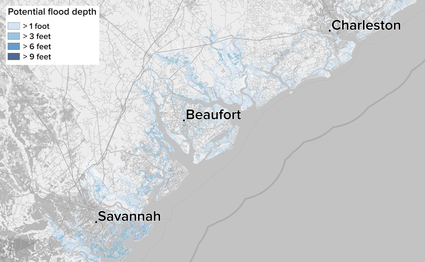
For now, Charleston and its neighboring cities should see a lesser storm surge, bringing flood depths only a little more than a foot deep.
Farther south, Savannah can see deeper inundation for its outer islands, with more than three feet projected for the Wassaw National Wildlife Refuge.
The Carolinas are particularly vulnerable overall to storm surges, noted Jeff Masters of Weather Underground, because the continental shelf extends less than 150 feet deep for 50 miles off the coast, which piles up water to “staggering heights.” The same quirk of geography helps explain the beautiful beaches that the states boast, wonders that have drawn in much of the development now threatened by the storm.
The National Hurricane Center calls the storm surge threat “life-threatening” in warnings issued for much of the coast.
“The biggest hazard that we’re worried about is storm surge. That’s the primary driver of the evacuations that are underway,” FEMA director Brock Long said Tuesday at a White House briefing. “If you have been told to leave, get out of areas that are going to flood.”
This is a developing story. Check back for updates and follow BuzzFeed News on Twitter.
UPDATE
Updated with latest storm surge flooding prediction maps.
UPDATE
Updated with latest predictions on storm surge flooding and information on the storm's likely track.
CORRECTION
Hurricane Hugo struck in 1989. An earlier version of this post misstated the year.
CORRECTION
Hurricane Florence could cause inland flooding similar to Hurricane Floyd and coastal flooding similar to Hurricane Hugo. An earlier version of this post misattributed the inland flooding comparison to Hugo.